Druk Path Trek
Explore The Worlds!
Description
Activities:
Trekking, cultural visits
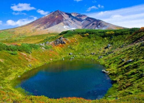
The Druk Path Trek through Bhutan’s beautiful countryside will let travelers experience its blue pine forest and sparsely populated areas. This is a relatively easy trek with a moderate grade leading from the Paro to Thimphu valley with elevations between 2400-4200m. One cool thing about this trek is in May when the rhododendron forests are in full bloom. You will also have views of Mt. Gangkar Puensum, the highest unclimbed mountain in the world with an elevation of 7,570 meters (24,836 ft).
Highlights:
Ta Dzong (National Museum), Jimgelang Tsho Lake, Look into nomadic lifestyle, views of Mount Gangkar Puensum, Phadjoding monastery
Season:
March-June/Sept-Nov
Included/Excluded
Tour Amenities
Tour Duration
Duration
Starting Price
From
Contact Us for pricing
Travel Style
Tour Type
Day by Day Itinerary
Distance 7 km, 4-5 hours, 1,090 m ascent, camp altitude 3,480 m.The first day can be quite arduous as you have to climb more than 1,000m elevation. You start from the Ta Dzong (National Museum) in Paro. The trek follows a gravel road past a few farms for about 30 minutes and then climbs up a steep ridge before leading through blue pine and fir forests to Damche Gom. Once you reach the ridge below Jili Dzong you descend about 100m to the campsite below the Dzong.
Distance 11 km, 4 hours, 230 m descent, 330 m ascent, camp altitude 3,870 m.
The trail follows a ridge and on a clear day the view of the mountains and valley are simply stunning. The campsite is close to the Jimgelang Tsho Lake. This lake is known for its giant sized trout.
Distance 11 km, 4 hours, 820 m ascent, 400 m descent, camp altitude 4,110 m.
The trail takes you through dwarf rhododendron trees and past Janetso Lake. You may come across some yak herder camps where you will have the opportunity to get a glimpse of a nomad’s life. The campsite is close to Simkotra Tsho Lake.
Distance 10 km, 3-4 hours, 130 m ascent, 680 m descent, camp altitude 3,750 m.
The day begins with a gradual climb. If the weather permits, you will have a spectacular view of Mount Gangkar Puensum, the highest mountain in Bhutan and several other Himalayan peaks. From this pass, the trek takes you downhill towards Phajodhing where you will halt for the night. The camp is located just above Phadjoding Monastery.
Distance 4-5 km, 3 hours, 1,130 m descent.
After passing Phadjoding monastery, the trek to Thimphu (Mothitang) is downhill through a forested area of mostly blue pine. The walk, at a leisurely pace, takes about three hours
Explore Tours
Activities:
Trekking, cultural visits
The Druk Path Trek through Bhutan’s beautiful countryside will let travelers experience its blue pine forest and sparsely populated areas. This is a relatively easy trek with a moderate grade leading from the Paro to Thimphu valley with elevations between 2400-4200m. One cool thing about this trek is in May when the rhododendron forests are in full bloom. You will also have views of Mt. Gangkar Puensum, the highest unclimbed mountain in the world with an elevation of 7,570 meters (24,836 ft).
Highlights:
Ta Dzong (National Museum), Jimgelang Tsho Lake, Look into nomadic lifestyle, views of Mount Gangkar Puensum, Phadjoding monastery
Season:
March-June/Sept-Nov
Included/Exclude
Tour Amenities
Tour Plan
Distance 7 km, 4-5 hours, 1,090 m ascent, camp altitude 3,480 m.The first day can be quite arduous as you have to climb more than 1,000m elevation. You start from the Ta Dzong (National Museum) in Paro. The trek follows a gravel road past a few farms for about 30 minutes and then climbs up a steep ridge before leading through blue pine and fir forests to Damche Gom. Once you reach the ridge below Jili Dzong you descend about 100m to the campsite below the Dzong.
Distance 11 km, 4 hours, 230 m descent, 330 m ascent, camp altitude 3,870 m.
The trail follows a ridge and on a clear day the view of the mountains and valley are simply stunning. The campsite is close to the Jimgelang Tsho Lake. This lake is known for its giant sized trout.
Distance 11 km, 4 hours, 820 m ascent, 400 m descent, camp altitude 4,110 m.
The trail takes you through dwarf rhododendron trees and past Janetso Lake. You may come across some yak herder camps where you will have the opportunity to get a glimpse of a nomad’s life. The campsite is close to Simkotra Tsho Lake.
Distance 10 km, 3-4 hours, 130 m ascent, 680 m descent, camp altitude 3,750 m.
The day begins with a gradual climb. If the weather permits, you will have a spectacular view of Mount Gangkar Puensum, the highest mountain in Bhutan and several other Himalayan peaks. From this pass, the trek takes you downhill towards Phajodhing where you will halt for the night. The camp is located just above Phadjoding Monastery.
Distance 4-5 km, 3 hours, 1,130 m descent.
After passing Phadjoding monastery, the trek to Thimphu (Mothitang) is downhill through a forested area of mostly blue pine. The walk, at a leisurely pace, takes about three hours